Potomac Overlook Regional Park and Donaldson Run


A view across the river into DC (Capital Crescent Trail)

I'm not sure one equates Arlington with the ideal hiking spot, but when a friend suggested we visit Potomac Overlook before stopping by her house, we decided to keep an open mind.  After all, there must at least be an awesome view of the river; it has an overlook, right?

Welcome all!

Potomac Overlook Regional Park and the adjacent Donaldson Run Park are typical suburban parks in that you are almost surrounded by houses on all sides, you aren't exactly in backcountry, nor are you "away from it all."  I mean, hey, the good news is you can't get lost!  Joking aside, it actually doesn't take very long to move into the woods and forget you are right outside of Washington, DC.

Heading into those woods

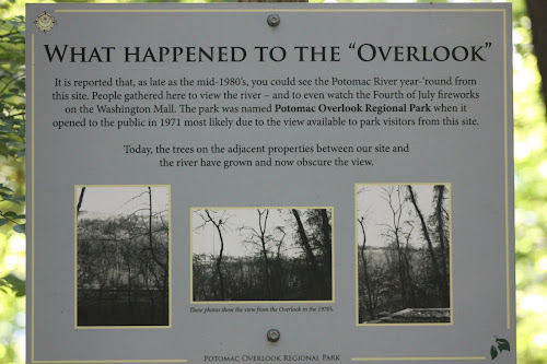
The upside to visiting any park for the first time is that you can't go wrong in terms of the route you choose. Everything is new to you.  After consulting the map, and a man walking his dog (people that frequent the park that you are in are 100% the best resource.  Infinitely better than any online review!), we decided to head straight to the overlook first.  We make our way down there only to be confronted with this sign:

Oh dear!  Our hopes sank a little.

This is the "Overlook," a partial view of the GW Parkway.

Not easily deterred or discouraged from the "overlook" we follow a secondary trail that isn't on the map, or my phone's GPS, which takes us parallel to the Parkway (slightly outside of the park's trail system) and eventually deposits us back into the park and deeper into the woods. 

The view substantially improves 👍

Appreciating a delicate ladybug🐞

This is the trail you want to be on.  I'm glad we eventually found it.  It takes you along Donaldson Run where you can crisscross the stream, play in the water if you so choose, and it will lead you down to the Potomac, and to the Potomac Heritage Trail.

Striking a pose 😉


Heading down to Donaldson Run

Our kids had different methods of getting down the dusty, loose rock/dirt trail 😏:

Method 1- The More Traditional Method:


Method 2- The Alternative:

😂  But why though?


I'm not sure you were "meant" to walk here.
Secondary trail?  Tertiary trail?  Deer trail?
Who knows? 

Once you do eventually reach Donaldson Run it becomes a little ambiguous where exactly the trail is a certain points.  You can pretty much walk on either side of the stream/creek (Donaldson Run) at most points.  The above looked like a path to me though.  My husband was not so sure about my "adventurous route".  But it was fun and we did end up back on the actual trail and down to the river where you can connect to the Potomac Heritage Trail.


A lot just got added to my hiking to-do list.
I definitely want to return and head off in both directions on the Potomac Heritage Trail.
100% worth it once we figured out where to go 😂

Donaldson Run depositing into the Potomac


Taking in the view of the Potomac before heading off to visit our friends, Greg and Erin.


I would absolutely return to Potomac Overlook Regional Park.  I would immediately head over to Donaldson Run and hop on the Potomac Heritage Trail.  The Donaldson Run trail was beautiful and interesting and if you have kids they will love repeatedly crossing or playing in the water.  From there you can easily hop onto the Potomac Heritage Trail for a nice hike.


Comments

  1. When you come back to do this let me know...I know a different, more direct way to get to Donaldson Run!

    ReplyDelete
  2. Yes, do let me know! It is always fun to explore though!

    ReplyDelete

Post a Comment

Popular posts from this blog

The White Mountains- Smart's Brook to Sandwich Mountain

Today was the first full day of our second trip to the White Mountains of New Hampshire.  I have been dreaming of returning since the moment we left this summer.  I knew my husband had a week off of work in October and I thought it would be a wonderful time to go back.  Once we decided to make reservations, I started buying and stashing non-perishable grocery items, preparing and freezing meals, heck, I even had the boys' and my suitcase packed a week in advance. Our trip north went well, although we took an hour longer (11 hours as opposed to 10 this summer) and it was raining the entire drive.  Luck would have it that when we drove in to Waterville Valley, the rain stopped, the sun came out and we were welcomed back with a beautiful rainbow.  I took it as a good omen. Once we arrived, we unpacked the car and went for a 5 mile walk along the Mad River, ate dinner, and went to bed dreaming of more adventures to come.  The following morning we all woke up ea...

Fraser Preserve, Great Falls, VA- Spring

They take conservation seriously there.  This amused me to no end. Conservation trash talk! Fraser Preserve is admittedly a new discovery to me and my family.  It was property given to the Nature Conservancy in the 70's that allows and encourages walkers to enjoy.  It doesn't have tremendous mileage in terms of trails, but you can easily extend your walk via their connector trail west into Seneca Regional Park via the fire road or Potomac Heritage trail or east via the Potomac Heritage Trail towards Riverbend (see my very detailed map below).  The actual preserve is rich in wildlife and lush vegetation.  Once you enter the park from the parking lot there is, what I named in my map, an unmarked "Obvious Dirt Trail" to the left.  Take it!  I have never seen so many toads and frogs in one place in all of my life.  I dubbed that "Frog Forest."  It is also a pretty spot to stop for a snack or to have a picnic lunch.  The "Obvious Dirt Trail"...

Greeley Ponds

We had been super lucky so far this vacation with the weather, but today Tropical Storm Isaias was making its way up the east coast and into our neck of the woods.  The good news was that it wasn't going to be in our area until late afternoon around 4:00 or 5:00 so we still had the majority of the day to get out and play.  Given yesterday's " 5 mile low-key hike " that ended up being 10+ miles, my kids had every reason to look at me skeptically when I told them this hike would be "easy" (I know, I know.  I wouldn't trust me either, but the hike really is rated as easy.  Promise 😉)  It runs partly along an old logging road, so it is soft, wide and not technical (rocky or root-y). You'll also notice that in the photo below the sign says Greeley Pond s , as in plural, more than one.  I don't know why, but I assumed it was only one pond.  Hikes are named imaginatively all the time, take for example a hike we did recently, Wolf Rock.  The sign sa...