Fletcher Cascade, Drakes Brook, and Jennings Peak

The highly underrated view from Jennings Peak

After driving slightly over an hour to see our dear friends, our youngest's BFF's family, we decided to try to stay close by and do a somewhat low-key hike.  We did a bit of Internet searching and settled on Drakes Brook which was a very short drive from where we were staying.  When you are online looking for hikes (let's say on a site like AllTrails), it can be very different when you arrive to the actual trailhead and are trying to figure out how the person writing the post strung together the "Moderate 5 mile loop."  My husband likes to go online and (try to) figure out the route in advance.  I do think it is good to have something of an idea of what certain trails are like.  But sometimes I can't figure out what they are talking about and just like to string a hike together on the fly.

We arrived at Drakes Brook and saw this sign.  

Drakes Brook trail is an out and back (Sandwich Mountain Trail would be the turn around point) so that would be 3.2 out + 3.2 back, round trip 6.4 miles.  You with me so far? So, 6.4 miles is pretty ideal.  But when we arrived and saw the sign, I thought, why not see the Cascade, it's barely over a mile. No big deal (The Fletcher Cascade trail splits off and heads the opposite direction).  Well, this wasn't fully calculating 0.4 to get to the trail + 1.6 to the Cascade = 2 miles and back down, 2 x 2 totaling 4 miles.  Then adding the 6.4 miles to Sandwich Mountain trail, so that would be a total hike of 10.4 😬.  See how it can get confusing?  Now, my kids have done a 10 mile hike before, but for obvious reasons (to avoid a ton of complaints making the experience miserable for everyone) we try not to do too many walks/hikes above about 5 or 6 miles- our personal sweet spot.

But it was too late, we were already well underway.  We saw the Cascade and came back down and headed up toward the Sandwich Mountain trail.  When we'd been ascending for quite a while and thought we should be pretty close to the end of Drakes Brook trail (the turnaround to come back down point) we saw an older couple coming down toward us.  We decided to ask them if we were almost there.  We were (thank God), but the woman had insisted that we should continue another .2 beyond where we had planned on turning around to Jennings Peak.  Apparently, the view was worth it.  Well, at that point, what's another .4???  Well, going up the last damn .2 you can feel it. It is steep (but manageable) at points.  She was right though, the view did not disappoint.  Jennings Peak is not as popular as some of the other summits (Jennings Peak is only 3,440 ft, not a famous 4,000 footer. (4,000 footers are a thing here, people try to hike all 48 of them in the White Mountains as a Bucket List kind of thing.)  Anyway, I was saying because it isn't 4,000 feet it doesn't get the foot traffic the other mountains get and we had the summit all to ourselves for a good 10 minutes to eat and take photos before heading back down.

I had 2 little troopers though.  We'd been out from about 8:30/9:00 to about 3:00, and were exhausted in the best kind of way when we returned.

I should also mention the trails had amazingly different and interesting mushrooms that the little one wanted me to photograph.  And there many or may not have been a toad or two 😉


And here we are settling into the wilderness, hike getting underway when:

The boys spotted toads.
I try to be patient as I know this is why they enjoy coming out.  
And I'll say, Little Brother is getting pretty good at toad spotting and catching in his own right.

😍 Look at that smile!  Gotta start the hike out happy.

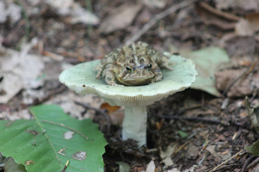
The boys had been wanting to stage this photo for so long.
They thought it would be so funny to have a toad on a toadstool, and like I said, 
interesting mushrooms are plentiful.
The toad was safely returned to the ground after the photo op 😂


The Little One got very interested in all of the different types of mushrooms.
We were impressed with the variety along the trails.
We have since ordered a book on fungi and mushroom identification 😊🍄
Below are some of the more interesting ones.

And before I go on, no one is touching or eating any of the mushrooms.  Just looking.

I'd never seen this before and we saw it in various colors.

More ordinary but interesting nevertheless

This one is a brown version of the interesting green/blue one the boys placed the toad on.

This hasn't been enhanced in anyway, it was shockingly vibrant.

These were striking!

Ghost Plant/Pipe or Indian Pipe
These aren't mushrooms but I thought they were cool.
 I had only seen these for the first time in the woods back
 in Virginia right before we left for NH.  
It can look waxy and transparent.  Here was a really bright, creamy example.  
It is a pretty unique plant.

A type of moss

Part of the Cascade

Back to the hiking though, here is about where the going got (really) tough.

I had a mishap with the mud 😄


Just...a...little...bit...farther...

Nearly there, still tough gradient though.

*Sigh*
This is what awaits.  It was worth it.
Honestly, I'd put this view only second to Osceola.
And bonus: waaaay less crowded👍

I'll leave you here with the view


Want to check out more New Hampshire:

Yes, an 11 and 7 year old climbed 4,000 ft Mt Osceola and Tecumseh

Cascade Path

Bear Brook State Park


Comments

  1. Wow! I'm impressed that they keep up with you guys! It looks amazing! Love the mushroom pictures...interesting find!

    ReplyDelete
  2. I've yet to intentionally set out on a 10 mile hike with them, and I think it needs to be done sparingly at their age, but I do believe, and know, they are capable. They can rightfully grumble when they are out there, but they are so proud of themselves afterwards. 10 miles is a lot, if you are an adult or child!

    ReplyDelete
  3. looks like a a great hike. Big Devil's Stairs in the Shenandoah NP should be easy after that one.
    P.S. we have plenty of mushrooms in the grass in our front yard. :P

    ReplyDelete
  4. Hahaha! We just saw an interesting yellow stemmed one with a bright red cap. So cool what's out there if you're looking!

    ReplyDelete

Post a Comment

Popular posts from this blog

The White Mountains- Smart's Brook to Sandwich Mountain

Today was the first full day of our second trip to the White Mountains of New Hampshire.  I have been dreaming of returning since the moment we left this summer.  I knew my husband had a week off of work in October and I thought it would be a wonderful time to go back.  Once we decided to make reservations, I started buying and stashing non-perishable grocery items, preparing and freezing meals, heck, I even had the boys' and my suitcase packed a week in advance. Our trip north went well, although we took an hour longer (11 hours as opposed to 10 this summer) and it was raining the entire drive.  Luck would have it that when we drove in to Waterville Valley, the rain stopped, the sun came out and we were welcomed back with a beautiful rainbow.  I took it as a good omen. Once we arrived, we unpacked the car and went for a 5 mile walk along the Mad River, ate dinner, and went to bed dreaming of more adventures to come.  The following morning we all woke up ea...

The White Mountains- East Osceola via Greeley Ponds

Not the summit, but still a spectacular view! In somewhat typical fashion for our family (beginning our time in New Hampshire with a bang (read: high mileage)), this trip started out with us attempting back to back 4,000 footers.  Why?  I'm not totally sure.  Perhaps we were feeling energetic having recently arrived, or more likely, the questionable weather forecast forced us to tackle some of our biggest hikes right away, before the impending rain.  Now, I know what you are thinking.  Yes, some hikes are completely doable in rain.  Soft trail, even trails that have tree roots are manageable, but steep and rocky terrain becomes dangerous in wet weather.  As do trails that feature cliffs or are otherwise described as "ledge-y."  I'd imagine that is what actually motivated us to check another of the 48 4,000 footers off of our list so soon: to take the weather out of the equation.   We settled on the East Peak of Mt. Osceola....

Greeley Ponds

We had been super lucky so far this vacation with the weather, but today Tropical Storm Isaias was making its way up the east coast and into our neck of the woods.  The good news was that it wasn't going to be in our area until late afternoon around 4:00 or 5:00 so we still had the majority of the day to get out and play.  Given yesterday's " 5 mile low-key hike " that ended up being 10+ miles, my kids had every reason to look at me skeptically when I told them this hike would be "easy" (I know, I know.  I wouldn't trust me either, but the hike really is rated as easy.  Promise 😉)  It runs partly along an old logging road, so it is soft, wide and not technical (rocky or root-y). You'll also notice that in the photo below the sign says Greeley Pond s , as in plural, more than one.  I don't know why, but I assumed it was only one pond.  Hikes are named imaginatively all the time, take for example a hike we did recently, Wolf Rock.  The sign sa...