The White Mountains- Snow's Mountain and The Scaur

The vista from Snows Mountain


This fall our trip to the White Mountains started off with some extreme mileage, a twelve mile hike (which is at least extreme to our kids), followed by two 4,000 footers.  Some times it is easy for me to get wrapped up in the "big" things like: how long is the hike, is it a famous/popular hike, is it a 4,000 footer, etc.?  But I've found that the  problem with that sort of focus is that you can potentially exhaust yourself physically and mentally (and your children!), and you tend to overlook some pretty amazing sights.  For instance, the day we drove to New Hampshire we arrived at about 4 p.m.  That is not enough time to do anything "substantial" but we walked from our house down to the river and followed the Mad River Trail for about a mile or 2.  It was gorgeous and the boys absolutely loved being along the water, the crossings, and all the rocks.  We probably would have never considered the hike otherwise.  Another such hike,  the one we chose to do the day after the 12 miler, was the East Pond Loop .  It is slightly less that 5 miles, there is no grand sweeping vista.  It turns out that the Little East Pond is pretty, and the East Pond absolutely takes your breath away.  That's another one that we could have easily missed.

The last two hikes of our trip were equally low key.  The first one, Snow's Mountain, I actually did alone.  It is 3 miles and in the valley where we were staying.  It is described as deceptively strenuous given its short length.  That sounded good to me I thought I'd check it out.  I walked to the trailhead from our house which added about 2 miles easy walking to the hike so that I'd have about a 5 mile total walk which is our sweet spot.  I took the hike clockwise which meant the beginning of the hike was climbing the mountain underneath a chairlift which is an interesting, although somewhat non-conventional way to start a hike (at least to this Virginian).  After climbing about a 3rd of the way up the mountain you head into the woods for a bit of an up and down ride with some pretty steep albeit short sections.  For the most part, the trail was well marked.  But hiking in the autumn with the fallen leaves can sometimes make for a "fun" time finding the trail, and if the paint has faded from the trees a bit, then you can have an especially "good time".  I may or may not have wandered around in the same spot for a good 10 minutes trying to figure out how to make the loop (as opposed to just turning around for an out and back).  I was never lost, I was always on the trail (which after reading heartbreaking stories such as this (please read it as a cautionary tail)), I NEVER let out of my sight.  I just couldn't figure out where it continued on.  I had taken photos on my phone of the local hiking map along with the description of the hike and was eventually able to figure out where to go.  It turns out the first overlook that I arrived to was off of an extension of the trail, not on the loop itself.  So, I did have to retrace my steps a bit before I got back to the loop.  I'm glad I sorted it out because the second view was wonderful.  All in all, it was a fun little hike, and I actually really enjoyed doing it alone.  I wouldn't want to hike alone all the time, or even often, but it was very refreshing to go at my own pace, stop when I wanted to stop, snack when I wanted, linger at the vista, and head back all when I wanted to.  An extra bonus: I saw zero humans.  Now, that is rare!


The trail begins walking up a ski lift area.

Hidden trail, hidden blazes on trees.
Where do I go?

There's the view.  It was worth taking the time to find the d@&% trail.

View from Snow's Mountain down into Waterville Valley.


Well, this hike both begins and ends in an unconventional way.
Ski lift to begin and walking out of the woods
 and pretty much onto someone's driveway to end!


Our very last hike this trip was a fitting send off.  It was a bright colorful, cool fall day, and the trail was on the gentler side with steady, rolling incline.  We saw two people and a dog the entire time.  When we arrived at the first viewpoint, The Scaur, there was no one there.  We sat, ate snacks, and luxuriated in the view.  The second lookout was about a mile further along and was in the opposite direction of the valley.  It wasn't a summit or even a rocky ledge.  It was simply through a break in the trees and let me tell you, the view did not disappoint.  So, go for those lesser travelled roads occasionally 😉

It will come as a surprise to absolutely no one that since returning home, I'm already plotting our return to New Hampshire next year.  I will sign off here, leaving you with the views 💚🌄🍁🍂


Howdy!

View of Mt. Tecumseh's ski slopes

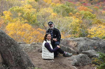
I call this "Life Contemplation."  It can be done on mountain tops or lake side 😊

On to View #2

The backside view


More New Hampshire Inspiration


Comments

Popular posts from this blog

The White Mountains- Smart's Brook to Sandwich Mountain

Today was the first full day of our second trip to the White Mountains of New Hampshire.  I have been dreaming of returning since the moment we left this summer.  I knew my husband had a week off of work in October and I thought it would be a wonderful time to go back.  Once we decided to make reservations, I started buying and stashing non-perishable grocery items, preparing and freezing meals, heck, I even had the boys' and my suitcase packed a week in advance. Our trip north went well, although we took an hour longer (11 hours as opposed to 10 this summer) and it was raining the entire drive.  Luck would have it that when we drove in to Waterville Valley, the rain stopped, the sun came out and we were welcomed back with a beautiful rainbow.  I took it as a good omen. Once we arrived, we unpacked the car and went for a 5 mile walk along the Mad River, ate dinner, and went to bed dreaming of more adventures to come.  The following morning we all woke up ea...

The White Mountains- East Osceola via Greeley Ponds

Not the summit, but still a spectacular view! In somewhat typical fashion for our family (beginning our time in New Hampshire with a bang (read: high mileage)), this trip started out with us attempting back to back 4,000 footers.  Why?  I'm not totally sure.  Perhaps we were feeling energetic having recently arrived, or more likely, the questionable weather forecast forced us to tackle some of our biggest hikes right away, before the impending rain.  Now, I know what you are thinking.  Yes, some hikes are completely doable in rain.  Soft trail, even trails that have tree roots are manageable, but steep and rocky terrain becomes dangerous in wet weather.  As do trails that feature cliffs or are otherwise described as "ledge-y."  I'd imagine that is what actually motivated us to check another of the 48 4,000 footers off of our list so soon: to take the weather out of the equation.   We settled on the East Peak of Mt. Osceola....

Greeley Ponds

We had been super lucky so far this vacation with the weather, but today Tropical Storm Isaias was making its way up the east coast and into our neck of the woods.  The good news was that it wasn't going to be in our area until late afternoon around 4:00 or 5:00 so we still had the majority of the day to get out and play.  Given yesterday's " 5 mile low-key hike " that ended up being 10+ miles, my kids had every reason to look at me skeptically when I told them this hike would be "easy" (I know, I know.  I wouldn't trust me either, but the hike really is rated as easy.  Promise 😉)  It runs partly along an old logging road, so it is soft, wide and not technical (rocky or root-y). You'll also notice that in the photo below the sign says Greeley Pond s , as in plural, more than one.  I don't know why, but I assumed it was only one pond.  Hikes are named imaginatively all the time, take for example a hike we did recently, Wolf Rock.  The sign sa...